
The first picture above shows Dias Geophysical´s QMAGT system, "a helicopter-borne magnetic survey system that measures the magnetic field in a robust and detailed manner", with its SQUID sensors operating within a liquid helium bath developed by Supracon AG of Jena, Germany. The second picture illustrates the northern part of the survey area with interpreted lithium pegmatites traced out with lines of white dots, whereas the third picture depicts the southwestern portion highlighting soil geo-chem results associated with the pegmatite swarm.
Disseminated on behalf of Lake Winn Resources Corp. and Zimtu Capital Corp.
Today, Lake Winn Resources Corp. announced final results from a hi-tech geophysics program, which appears to have successfully mapped the LCT (lithium-cesium-tantalum) pegmatites at its LNPG (“Little Nahanni Pegmatite Group“) Property in Northwest Territories, Canada. According to Rockstone´s previous report on Lake Winn in January, the LNPG Project was denoted as "an awakening giant". With the geophysics results now at hand, the delineated pegmatites running below surface indeed look gigantic, indicating that there may be a wider and longer system of interconnected lithium pegmatites than previously thought.
The known pegmatites at LNPG, outcropping at surface, were channel-sampled and drill-tested in the past, demonstrating that the system is well-mineralized with high grades of lithium. Historic drill hole MAC06 encountered 17.96 m @ 1.03% LiO2, whereas historic hole MAC07 intersected 10.94 m @ 1.47% LiO2 from the same drill pad with a different dip. Historic channel sampling confirmed numerous pegmatite dykes as strongly mineralized with >1% LiO2 over 1 to 16.65 m intervals.
The geophysics results show impressively that the identified anomalies coincide with the known pegmatites, indicating to connect into numerous larger anomalies which range from 10 to 100 m widths and can be intermittently traced along strike for up to 7 km.
With these awe-inspiring geophysics results in plain sight, Lake Winn is eager to drill-test these anomalies as quickly as possible and is currently planning a 3,000 m drilling program (already permitted) to start in early August. Lake Winn´s CEO, Patrick Power, commented in today´s news: “We took a bit of a risk with using the relatively new QMAGT system but as you can see it has proven worthy, this will greatly aid in our upcoming drill program. The more we work on this property the more it becomes apparent that we have a large system of LCT pegmatite dykes, our goal is to as quickly as possible narrow down the best zones in this system which stretches more than 7 kilometers. Our vision is to define circa 100mT of >1% LiO2 in the most rapid low-cost manner. This summer’s work will be a big step towards making this a reality."
Before quoting Lake Winn´s full news-release below, note that the previous Rockstone report provided below figure (“Idealized Pegmatite System“) stating that this might be the most important aspect to understand Lake Winn‘s exploration model for the LNPG Property going forward. With today´s geophysics results, the model may have shifted towards individual pegmatite dykes near surface running much longer and wider across the property than previously thought.

Full size / Cross-section through an idealized pegmatite system with interpreted erosion levels (sections) of the LNPG Property in comparison with the Greenbushes Lithium Pegmatite Deposit in Western Australia.
The above figure shows the historically interpreted erosion level of the LNPG Property in comparison to the Greenbushes Deposit in Australia, which is the world‘s largest hard-rock lithium mine in terms of reserves, resources, production, and capacity, producing 1.95 million t of lithium spodumene annually (2019). It is renowned for containing the world‘s highest-grade quality lithium spodumene. The previous Rockstone report showed that the lithium grades encountered by historic channel sampling at LNPG in 2016 are in line with Greenbushes´ average lithium deposit grades as of 1995.

Full size / Source / The Greenbushes Mine is owned and operated by Talison Lithium PLC (since 2014 a joint venture between Tianqi Lithium Corp. and Albemarle Corp.), whose website states the following: “The Greenbushes pegmatites belong to the Lithium-Caesium-Tantalum family...The pegmatite consists of a large main zone over 3 kms long and up to 300 m wide with numerous smaller pegmatite dykes and pods flanking the main body. The Greenbushes pegmatites are mineralogically zoned in a lenticular interfingering style along strike and down dip... Talison Lithium and its predecessor companies have been producing lithium from the Greenbushes lithium operations since 1983 and Greenbushes is recognised as the longest continuously operated mining area in Western Australia... [The] Greenbushes pegmatite is a giant pegmatite dike of Archean age with substantial Li-Sn-Ta mineralization, including half the world’s tantalum resource.” The Greenbushes Mine is estimated to have resources of 8.7 million t LCE and reserves of 6.8 million t LCE. (Source)

Full size / Samples of high-grade lithium mineralization outcropping at the LNPG Property. (Source: Technical Report “Geology and Summary Report of the Little Nahanni Pegmatite Prospect”, 2017)
Lake Winn´s full news-release today:
Leading Edge MAG SYSTEM, Maps Extensive Lithium Bearing Pegmatite Dyke Swarm, LNPG Project, NWT
Highlights
• Final results from Hi-tech full tensor ultrasensitive magnetic survey received.
• The system appears to successfully map the LCT pegmatite dykes, illustrating that there may be a wider and longer system of anastomosing dykes than previously thought.
• Signatures up to 100 m wide.
• Drilling and channel samples confirmed multiple 1% LiO dyke intervals over 1 m width with coincident elevated Ta, Sn, and Cs values.
• Historic soil sampling in a heavily treed area in the southeastern part of the property identified coincident Li, Ta, Sn, and Cs values. The QMAGT system identified a large vertical magnetic gradient anomaly (Alpha Prime) coincident with the soil anomaly.
• The drill program planned for August and is already permitted.
Vancouver, British Columbia – July, 6th 2023 – Lake Winn Resources Corp. (“Lake Winn” or the “Company”) (TSXV:LWR) (FSE:EE1A) is pleased to announce that it has received the final processed data from Dias Geophysical QMAGT system. We believe that the QMAGT system has successfully mapped the LCT pegmatite dyke swarm. Anomalies coinciding with the known dykes appear to coalesce into numerous larger anomalies which range from 10 m to 100m widths and can be intermittently traced along strike for up to 7 km. Historic drilling and channel sampling has proven numerous intervals of mineralized pegmatite grading >1% LiO2 over 1 m to 16.65 m intervals. The QMAGT results will greatly assist the upcoming field mapping and drill program.
QMAGT System
The QMAGT system is a helicopter-borne magnetic survey system utilizing a SQUID (superconducting quantum interference device) sensor measures the complete gradient tensor of the earth’s magnetic field. The SQUID sensors are developed by Supracon AG of Jena, Germany. Operating within a liquid helium bath, the sensors measure the magnetic field with great sensitivity. The survey was not without its challenges due to weather and topography, the system lost sensitivity over the steep cirque valleys (difficult to drape by any system) and in the last flight when it was running low on helium. Elsewhere the system delivered numerous vector products of excellent quality. These will be passed on to consultants to model the magnetic sources in 3-D, a task the vector data is well suited for. For this news release we will focus on the Bzz data channel which maps the vertical magnetic gradient.
Vertical Gradient Results and Interpretation
Figure 1 shows a colored grid map of the Bzz data channel from the survey, the left image is colored, so the zones of high gradient are the “hot” red colors, the right image is colored by reversing the palette so that the zones of low gradient are the “hot” red colors. The current thinking is that the LCT pegmatites have very little magnetic response, so they are the zones of low gradient, whereas when they were intruded into the surrounding sandstones, a hornfels was formed causing the high vertical gradients. The red colors in the right image of Figure 1 thought to map directly the LCT pegmatite dykes. It is an exciting result. Other vectors like Bxy (not shown) support this interpretation with coincident anomalies matching the reds in the reverse color image for Bzz. The results show a dense swarm of pegmatites, tens of metres across near northern drill holes. Drill hole MAC06 encountered 17.96 m of LCT pegmatite grading 1.03% LiO2 and drill MAC07 drilled from the same site at a 60° dip encountered 10.94 m of LCT pegmatite grading 1.47% LiO2 (Figure 2). In Figure 1 a strong LCT pegmatite response can be seen semi-continuous over the entire property measuring approximately 100 m across over many kilometres. Close inspection of nearby historic collars suggest they drilled near but above this target. One of the first tasks for our field crews this summer will be to ground truth these anomalies.
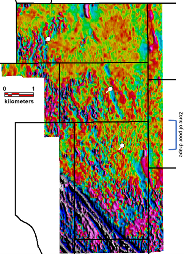
Full size (left) / Full size (right)
Figure 1 (Left Image): Bzz (Measured vertical Gradient) flown over the center portion of the LNPG project in the NWT near the Yukon border. White dots are the historic drill holes with their traces. The long linear, “red” responses (high vertical gradient) are interpreted as hornfels (heat altered sediments) that brace either side of the pegmatite dykes which are mapped as “Blue” zones of lower vertical gradient. (Right Image) The same Bzz data image with the color system reversed to highlight the interpreted pegmatite dykes as “Red” zones, for easier interpretation.
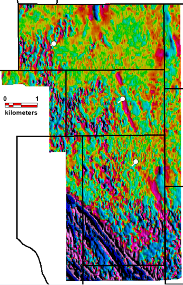
Figure 2 illustrates the northern part of the surveyed area, around drill holes MAC 06 and 07, with the reverse-colored image from Figure 1 (Right Image) and overlain by topographic contours. It is clear from the contours where there are deep cirque valleys a couple of hundred metres deep the helicopter was not able to drape and follow the terrain, making the distance from ground to sensor greater and the image gets “washed” out with less detail. The interpreted LCT pegmatite dykes have been traced out with lines of white dots. They seem to get cut-off by the cirques, but we know from outcrop they persist in the cliff faces of the cirques. The apparent cut-off is due to loss of sensitivity due to the height above the ground. Signal drops off at the square of the distance. On the upper plateau, a swarm of anastomosing dykes can be perceived including the dyke that was sampled by MAC 06 and 07. Part of the summer field program plan is to expand on the intercepts in these holes using 50 m step outs. This magnetic data will aid in locating these collars.
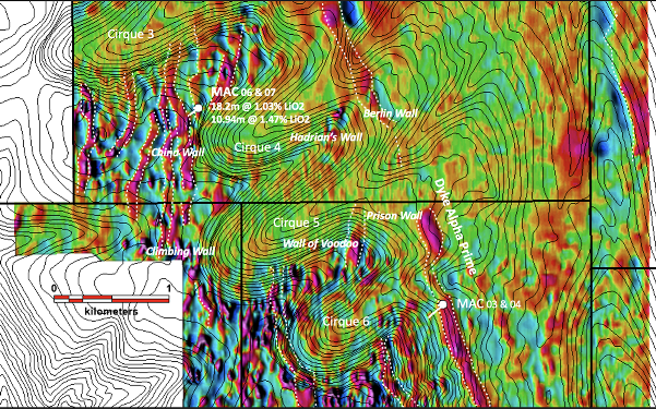
Figure 2: A zoomed in view of the NW part of the property, with the Bzz data, reverse colors, with 5 m topographic contours. The red linears are thought to map out the LCT pegmatite dykes. Note the swarm near historic drill holes MAC06 and MAC07, at which these drill holes only test one dyke in the swarm. The channel sample highlights are shown in Table 1, below.
In the past field crews sampled the exposed pegmatite outcrop in the faces of the cliffs that define the cirques, the cliff faces were given colloquial names after famous “walls.” Table 1 lists the channel samples from the various cliff faces sampled. The small dykes sampled in Table 1 would not be able to be resolved in the magnetic data due to the small width, only the larger dykes and the combined swarms will show. Refer to Figure 2 for locations. The dyke swarm seems to continue in the magnetic data to the south past Cirque 6 in an unexplored part of the property. Figure 2 also illustrates an 80 m to 100m wide magnetic signature that traverses the entire data set for several kilometers. This anomaly has been named Alpha Prime. Several scout drill holes are planned to test these, this summer.

2006-2007 Soil sampling correspondence with the southern extent Alpha Prime pegmatite dyke
The concept that the Alpha Prime dyke, is part of the LCT pegmatite swarm, is supported by soil sampling undertaken in the south end of the property in 2006 and 2007. These soil surveys used two assay methods, one with Aqua Regia for a selected digest, and one using four-acid near total digest. Lithium was only assayed for in the near total digest. Figure 3 shows the results of this work. The trace of Alpha Prime has a strong (red circles) > 127 ppm Li-in-soil anomaly coincidence with it.
Full size
Figure 3: SW portion of the QMAGT survey, colors changed (to pastel purple) to highlight the soil geo-chem results associated with the pegmatite swarm. The Alpha Prime dyke signature is prominent and named in the figure. Each dot represents a soil sample site, the dots have been colored by Li ppm results as shown in the legend.
Soil sampling seems to be an effective tool in this environment, and there are plans to expand this soil grid in key areas of interest, to follow Alpha Prime, and to define the dyke swarms on the plateau near Cirques 3 to 6.
Patrick Power, CEO of Lake Winn Resources Ltd said, “We took a bit of a risk with using the relatively new QMAGT system but as you can see it has proven worthy, this will greatly aid in our upcoming drill program. The more we work on this property the more it becomes apparent that we have a large system of LCT pegmatite dykes, our goal is to as quickly as possible narrow down the best zones in this system which stretches more than 7 kilometers. Our vision is to define circa 100mT of >1% LiO2 in the most rapid low-cost manner. This summer’s work will be a big step towards making this a reality.
Lake Winn is currently in planning with our consultants, Archer, Cathro & Associates (1981) Limited, to scope, price, and plan a 3,000m drill program to commence in early August.
The technical information in this news release has been approved by Heather Burrell, P.Geo., a senior geologist with Archer, Cathro & Associates (1981) Limited and a qualified person for the purpose of National Instrument 43-101.
About Lake Winn
Lake Winn Resources Corp. is a mineral exploration company focused on advancing its 100% owned Little Nahanni Lithium Project (“LNLP”), which is located in the western Northwest Territories near the Yukon Border. The project covers 7,080 hectares that encompasses a 7 km long, and up to 500 m wide, lithium, tantalum, and tin pegmatite dyke swarm. Historical drilling and channel sampling on the Project confirms the presence of significant Lithium, Tantalum, Tin, and Cesium.
On Behalf of the Board of Directors of Lake Winn Resources Corp.
Patrick Power
CEO and Director
Lake Winn Resources Corp.
Telephone: (604) 218-8772
“Neither TSX Venture Exchange nor its Regulation Services Provider (as that term is defined in the policies of the TSX Venture Exchange) accepts responsibility for the adequacy or accuracy of this release.”

Full size / Source / The LNPG Property is located 30 km northwest of the Cantung Tungsten Mine, which operated from 1962 to 1986, again from 2002 to 2003, and from 2005. Production was suspended from October 2009 to October 2010. The mine owner, North American Tungsten Corp., went bankrupt in 2015 and the mine closed in October of that year. The federal government of Canada now owns the mine. As of 2017, the mine remained closed, with the possibility of being opened to process a nearby lithium deposit.
The Howard‘s Pass district is one of the largest undeveloped Zn-Pb districts in the world. Within the interior Cordillera of northwestern Canada, the Howard’s Pass Zn-Pb district extends for over 40 km and consists of 15 currently undeveloped orebodies. These Zn-Pb deposits are hosted in strata of the Selwyn basin and have been classified as sedimentary exhalative (SEDEX) type. Collectively, they contain more than 154 million t of indicated resources and 237 million t of inferred resources. The Howard’s Pass district of sedimentary exhalative (SEDEX) Zn-Pb deposits comprises 14 Zn-Pb deposits that contain an estimated 400.7 million t of sulfide mineralization grading 4.5% Zn and 1.5% Pb. The Howard‘s Pass district is located within the Selwyn Basin, a metallogenic province that is primarily known for its worldclass Zn-Pb (±Ag ± Ba) sediment-hosted deposits.
Company Details

Lake Winn Resources Corp.
Suite 1100 – 1111 Melville Street
Vancouver, B.C. V6E 3V6 Canada
Phone: +1 604 218 8772
Email: info@lakewinn.ca
www.lakewinn.ca
CUSIP: 511305 / ISIN: CA5113051042
Shares Issued & Outstanding: 68,971,639

Canadian Symbol (TSX.V): LWR
Current Price: $0.075 CAD (07/05/2023)
Market Capitalization: $5 Million CAD

German Symbol / WKN: EE1A/ A2QERM
Current Price: €0.032 (07/05/2023)
Market Capitalization: €2 Million EUR
Contact:
www.rockstone-research.com
Disclaimer: This report contains forward-looking information or forward-looking statements (collectively "forward-looking information") within the meaning of applicable securities laws. Forward-looking information is typically identified by words such as: "believe", "expect", "anticipate", "intend", "estimate", "potentially" and similar expressions, or are those, which, by their nature, refer to future events. Rockstone Research, Lake Winn Resources Corp. and Zimtu Capital Corp. caution investors that any forward-looking information provided herein is not a guarantee of future results or performance, and that actual results may differ materially from those in forward-looking information as a result of various factors. The reader is referred to Lake Winn Resources Corp.´s public filings for a more complete discussion of such risk factors and their potential effects which may be accessed through its profile on SEDAR at www.sedar.com. Please read the full disclaimer within the full research report as a PDF (here) as fundamental risks and conflicts of interest exist. The author, Stephan Bogner, holds an equity position in Lake Winn Resources Corp., as well as in Zimtu Capital Corp., and is being paid by Zimtu Capital Corp. for the preparation, publication and distribution of this report, whereas Zimtu Capital Corp. also holds a long position in Lake Winn Resources Corp. Note that Lake Winn Resources Corp. pays Zimtu Capital Corp. to provide this report and other investor awareness services.
