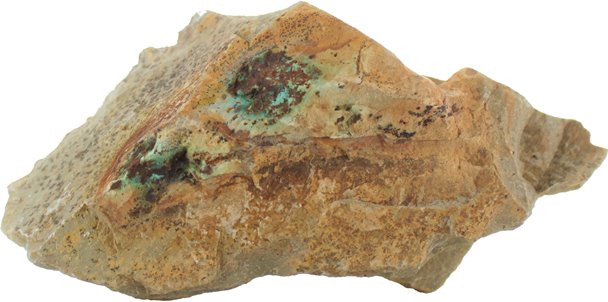
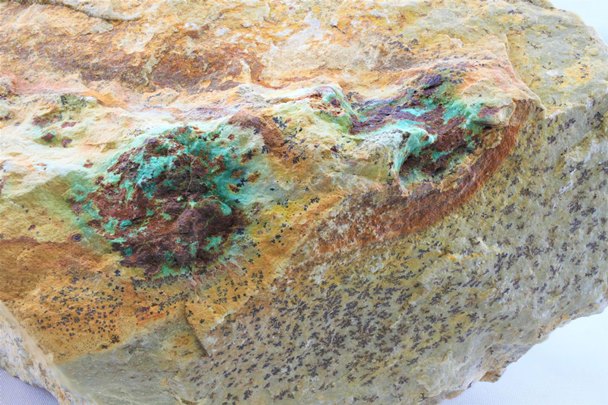
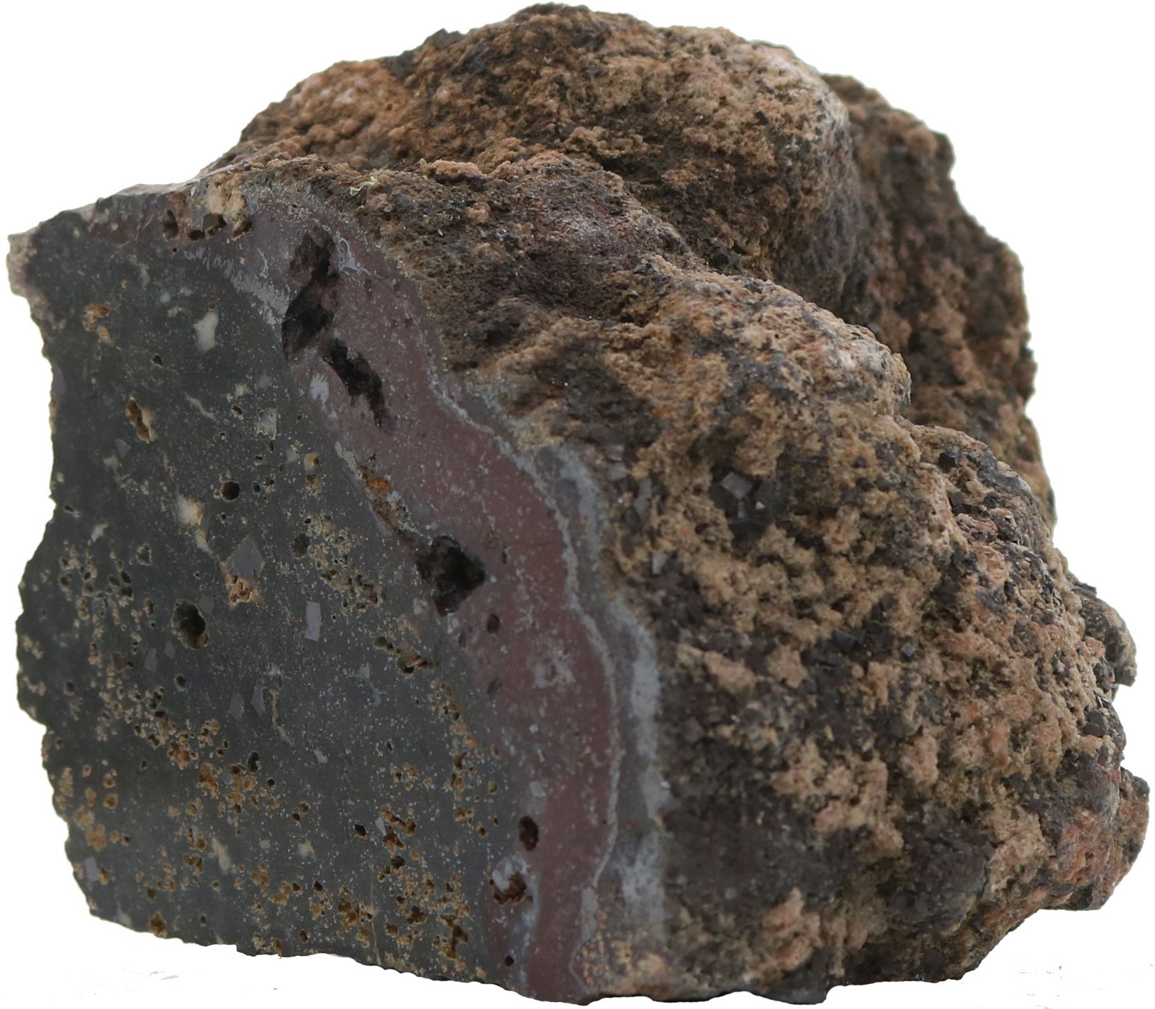
Full size / Copper from the Koo Trend on Aeonian‘s Koocanusa Property in British Columbia: Azurite and malachite staining around weathered sulphide blebs in a dolomitic rock unit. This was one sample collected within a 130 m mineralized road-section within the main Koo Trend.
Disseminated on behalf of Aeonian Resources Ltd. and Zimtu Capital Corp.
An increasing number of major mining companies is attracted by deposits to be mined underground – not only because the surficial disturbance and environmental impacts are less than with open-pits but also because these can be highly economic due to low operating costs. In this regard, among the most attractive deposit-types is sediment-hosted copper as its ore zone typically runs continuously for long distances (up to several kilometres, or hundreds to a thousand kilometres through Germany and Poland or the prolific Congo Copper Belt). And when the width of the ore zone is just a metre (or even less!), that‘s just great news for underground mining engineers and shareholders alike.
The famous Kootenay Gold Rush was ignited when placer gold nuggets weighing as much as a kilogram were found in the Wildhorse River close to Cranbrook in southern British Columbia. Alone the Wild Horse River produced ~1.5 million ounces of gold in 1863-1930s. Aeonian‘s Koocanusa Property is just 20 km southwest of the Wild Horse River. Placer mining at Aeonion‘s Gold Creek and the immediate area has a long and productive history. The source of all the gold has never been found yet, but Aeonian found mounting evidence for another deposit-type on its district-scale land holdings spanning over 130 km2: Sediment-hosted copper.
Members of Aeonian‘s management team will be joining this years‘ Zimtu Road-Trip in Switzerland (Geneva and Zurich) and Germany (Frankfurt and Munich) on November 1-5, 2022. To meet Aeonian‘s management team and other CEOs of Canadian-listed exploration, green-tech and sports-gear companies, secure your spot at select event locations by clicking here.

Although not listed on a stock-exchange, investors can already participate in a potential discovery by participating in a private placement financing as the private company has an intent to become publicly traded on a Canadian stock-exchange. Aeonian Resources Ltd. is a private company founded in 2020 and is currently in the process of getting listed on the Canadian Securities Exchange. Aeonian started exploration at its Koocanusa Copper Project in southern British Columbia in 2020 and continued work in 2021 and 2022. Currently, the company is doing a private placement financing at a price of $0.05 per unit, which includes one common share of the company and one warrant exercisable into a share at a price of $0.10 in the first year and $0.25 in the second year (from the date the company’s shares commence trading on the Canadian Securities Exchange).
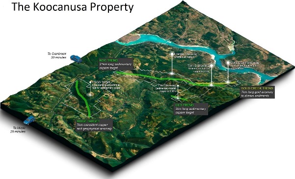
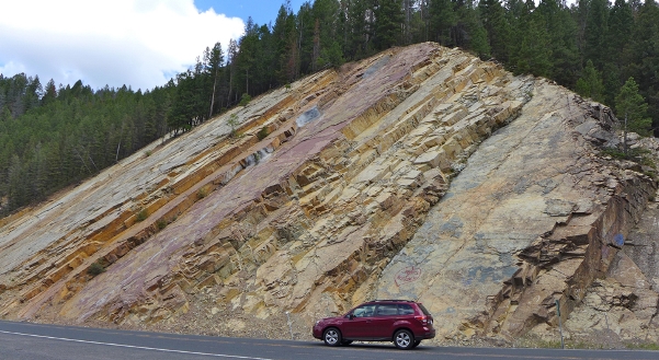
Full size / The Koocanusa Project is an exciting re-imagining of an ancient geological system located 30 km southeast of Cranbrook in British Columbia. The project is road-accessible year round and enjoys a favorable position close to infrastructure and supply centers. Active logging in the area for decades has resulted in over 300 km of drivable trails within the property boundary. Cranbrook and the surrounding area have a long history of mining and forestry services and is therefore extremely well set up for supplies, services and experienced personnel. North of Cranbrook in Kimberly, the Sullivan Mine operated for over 90 years, whilst Teck has a large coal operation to the east at Sparwood. The area has active interest groups including the East Kootenay Chamber of Mines and the regional government office for the Ministry of Energy, Mines & Resources. Most of the property has never seen any exploration.
The Koocanusa Property boasts a fantastic location with road access, a long exploration season, well-developed support services and infrastructure close-by.
Hosted in some of the oldest rocks in British Columbia, Koocanusa has both sedimentary copper and epithermal gold showings with potential for additional cobalt and silver. Placer gold has been panned from Gold Creek since the 1860s although the source of the gold has not been found. The region was last explored in the 1980s and since that time, equivalent rocks in the US have been found to host economic copper, cobalt and silver deposits.
Aeonian is trawling historical data, academic papers and economic assessments of similar projects to build a new geological model. This, coupled with advances in technology, broad geochemical sampling and detailed mapping, is increasing Aeonian‘s understanding – and the potential – of the Koocanusa Project.
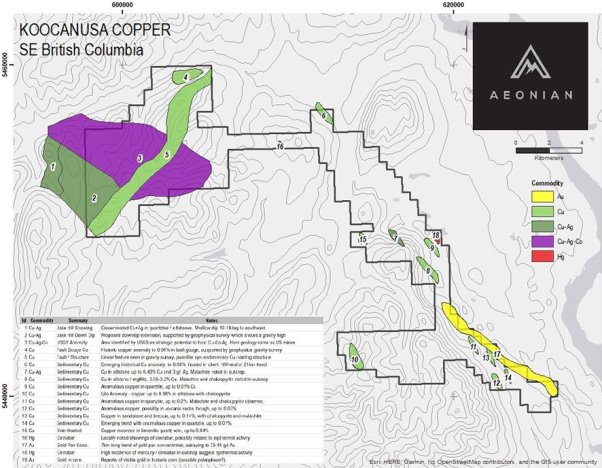
Preliminary prospecting at Koocanusa has highlighted anomalous copper trends that run parallel to bedding in coarser siltstone and sandstone layers, with at least 2 prospective horizons identified to-date. In addition to the sediment-hosted copper, there is evidence of overprinting epithermal veins which may be contributing to the anomalous historic gold occurrences noted on Aeonian‘s property.
Koocanusa Highlights
• Over 130 km2 of road accessible continuous mineral tenures 30 minutes from Cranbrook, BC, from where the project site is accessible by Highway #3 and the Newgate-Kikomun Forestry Road. The Koocanusa Property is serviced by an extensive and well-maintained network of roads and trails.
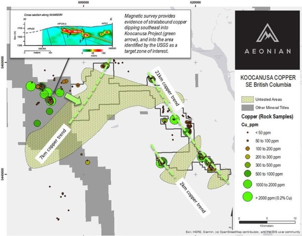
• 21 km continuous trend of anomalous copper following prospective stratigraphy, with historic surface rock samples showing up to 0.98% copper from sedimentary-hosted units.
• Targets located in the western part of the property are associated with known copper-silver showings and down-dip extensions identified during a Critical Minerals Survey by USGS (United States Geological Survey).
• Some target zones hosted in equivalent strata to Hecla-owned copper-silver-cobalt deposits in Montana, 120 km south.
• Historic drilling intersected 1.6 m @ 0.85% copper.
• Visible gold reported in historic (1989) drill core at the Gold Creek showing (source of gold yet to be found).
• Historic pan concentrates highlight a 7 km long anomaly with up to 75.46 g/t gold along the creek.
• 2020 field work suggests the presence of several potential copper horizons hosted in sandstone units dipping 10-45 degrees, which would have been missed by historic exploration/drilling methods.
In October 2020, Aeonian completed a prospecting program with a group of 4 geoscientists. The entire property was covered, with over 100 field data points collected (structural and lithological data) along with 40 geochemical samples. This work was pivotal in identifying the primary copper trends.
In June 2021, Aeonian‘s team completed a 2 x 1 km magnetic survey grid with coincident soils over a central section of the Koo Trend, with additional prospecting, mapping and sampling activities in newly staked areas.
In August 2022, Aeonian announced that its Phase 1 Exploration Program was completed during a 3-week period from July 20 to August 12:
• Exploration was primarily focused on the southeastern and central part of the property within the 21-km mineralization trend, and included district-scale geological mapping, construction of stratigraphic columns, conduction of structural measurements, and documenting locations of faults, folds, foliation, veins, and fractures. Aeonian also completed several reconnaissance trips around the western part of the property and identified a potential new target called the Jim Creek Zone. To complement the mapping and observations, a detailed geochemical analysis with an μXRF instrument on key stratigraphic intervals from the outcrops was completed. The integration of the Phase 1 results allowed Aeonian to constrain the sedimentary sequences that host the mineralization including the lateral extent and lithological variability, which is a key factor in predictive modeling. Aeonian also completed several drone survey grids to create a 3D terrain model over the mapped section 21-km trend which will help with determining future projections of the “fertile” sedimentary horizons.
• Phase 2 commenced on August 20 and will continue to build on the profile of the area, with a focus on the new Jim Creek Zone, possible extensions of mineralization along the Koo Trend, and mapping around the Gilnockie Target in the south.
• Aeonian‘s President and CEO, Branden Haynes, commented in the August-2022-news: “The Board of Aeonian Resources is happy with the results of Phase 1 on Koocanusa and is optimistic for Phase 2. This summer’s exploration program adds additional expenditure value to the Koocanusa project that already has a NI 43-101 report.“
With initial prospecting and phase-1 of the 2022 exploration program completed – and highly prospective and viable targets established – the next exploration steps aim to discover a sediment-hosted copper deposit in one of the world‘s most favorable terrains – maybe just in time with Aeonian‘s plans for a listing on a Canadian stock-exchange.
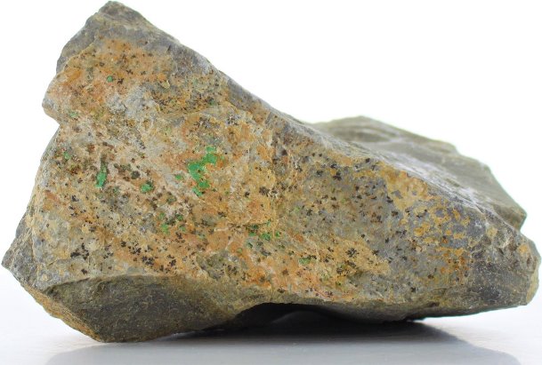
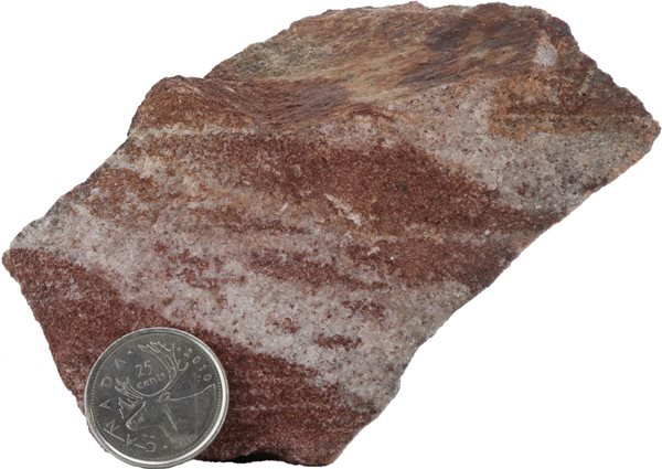
Copper mineralization has been observed at a variety of locations across the Koocanusa Property. The most notable are the copper carbonates and oxides (malachite, azurite, chrysocolla) which form green stains on surfaces and along fractures. Within fresh rock Aeonian observed chalcopyrite and chalcocite mineralization. The “copper fronts” are associated with sandstones or dolomitic units, although weaker mineralization has also been observed in chert and mudstone. Manganese dendrites, cubic pyrite, magnetite and garnets are all accessory to the copper fronts and are good pathfinders in the field.
The rocks at Aeonian‘s Koocanusa Property are part of the Purcell Basin Supergroup which underlie southeastern British Columbia and stretch into Montana and Idaho, USA. There are similarities at Koocanusa to several major deposits and mines in Montana, where copper and silver is hosted in porous sandstone beds (below mentioned deposits and mines are all owned by Hecla Mining Company; NYSE: HL; current market capitalization: $2.8 billion USD):
Rock Creek Deposit (Montana):
100 million t @ 47 g/t silver and 0.7% copper containing 148 million ounces silver and 658,680 t [1.5 billion pounds] copper (Inferred, 2020).
In 2015, Hecla acquired Revett Mining Company Inc. and its Rock Creek Project, which is “considered to be one of the largest undeveloped silver and copper deposits in North America“, according to Hecla. The 130-year-old Coeur d’Alene-based miner acquired all the outstanding shares of Revett for total consideration of approximately $19 million in Hecla stock. As such, Hecla recognized early the significance of Rock Creek and opportunistically took over Revett during a downturn in the precious and base metals markets.
According to Hecla‘s website: “The Rock Creek project is located approximately five miles northeast of Noxon, Sanders County, Montana (about 50 miles north of [Hecla‘s] Lucky Friday mine in Idaho). Inferred resource at Rock Creek reported at a minimum thickness of 15 feet [~4.6 m]; Metallurgical recoveries: 88% silver, 92% copper.“
Revett “had planned to develop Rock Creek as an approximate 10,000-st/d, underground room-and-pillar mine similar to Troy [a past producing, near-by sedimentary silver-copper mine]. Processing would be based on conventional crushing, grinding, and flotation to produce a copper-silver concentrate that would be shipped by rail to a smelter.“ Hecla‘s CEO stated in May 2015: “We are acquiring Revett with an eye to the future, as Rock Creek is a world-class silver-copper deposit...“
Montanore Deposit (Montana):
112 million t @ 50 g/t silver and 0.7% copper containing 183 million ounces silver and 759,420 t [1.7 billion pounds] copper (Inferred, 2020).
In 2016, Hecla acquired Mines Management Inc. and its Montanore Project, which is “considered one of the largest undeveloped silver and copper deposits in North America“. The project is approximately 10 miles from Hecla’s Rock Creek project...“ Hecla acquired all the outstanding shares of Mines Management for total consideration of approximately $46 million in Hecla stock, representing a 41% premium to Mines Management‘s share price on May 20, 2016.
According to Hecla‘s website: “Geologically, the deposit is categorized as a stratabound sediment-hosted silver-copper deposit, and is one of three major deposits in the area, including the Troy Mine and Rock Creek deposit.“
Hecla‘s CEO stated in May 2015: ”Hecla is the logical company to move Montanore forward, with its close proximity to Rock Creek, as well as its similar geology and scale. We have considerable experience operating Greens Creek in a National Monument which will, combined with our financial strength and commitment to the community and environment, help Montanore reach its full potential.”

Excerpts from a Scientific Investigations Report by the USGS (2005):
“The western Montana copper belt in western Montana and northern Idaho contains several large stratabound copper-silver deposits... Production from the deposits at the Troy Mine and lesser production from the Snowstorm Mine has yielded 222,237 tons [490 million pounds] Cu and 1,657.4 tons [53 million ounces] Ag. Estimates of undeveloped resources, mostly from the world-class Rock Creek-Montanore deposits, as well as lesser amounts at the Troy Mine, total more than 2.9 million tons [6.4 billion pounds] Cu and 2,600 tons [84 million ounces] Ag in 406 million tons of ore. The Rock Creek-Montanore and Troy deposits, which are currently the most significant undeveloped resources identified in the copper belt, are also among the largest stratabound copper-silver deposits in North America and contain about 15 percent of the copper in such deposits in North America... These [stratabound copper-silver] deposits typically consist of disseminated Cu sulfide minerals restricted to a narrow range of mineralized layers within a sedimentary sequence... Mineral deposits in the Revett Formation are unusual because they are also rich in silver, a characteristic that sets them apart from many other stratabound copper deposits...“
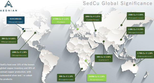
Sedimentary copper deposits supply about 20-25% of the world‘s copper production, ranking second (after porphyries) as the most important copper deposit-types. Sediment-hosted copper deposits may also contain silver, gold, PGEs and other rare metals.
“Porphyry copper deposits, which are associated with igneous [magmatic] intrusions, yield about two-thirds of the world‘s copper and are therefore the world‘s most important type of copper deposit. Large copper deposits of this type are found in mountainous regions of western North America and in the Andes Mountains of South America. Another important type of copper deposit – the type contained in sedimentary rocks – accounts for approximately one fourth of the world‘s identified copper resources. These deposits occur in such areas as the copper belt of central Africa and the Zechstein basin of Eastern Europe.“ (Source)
“Sediment-hosted copper deposits are stratabound, that is, they are restricted to a narrow range of layers within a sedimentary sequence but do not necessarily follow sedimentary bedding. They are epigenetic and diagenetic, that is, they are formed after the host sediment is deposited, but in most cases, prior to lithification of the host. They form independently of igneous processes... Host rocks are of two types: low-energy calcareous or dolomitic siltstones, shales and carbonate rocks of marine or lacustrine origin; and high-energy sandstones, arkoses and conglomerates of continental origin... All deposits contain one or more of the following minerals deposited in zones in this order: chalcocite and other copper sulfide minerals, bornite, chalcopyrite, pyrite, and subordinate galena and sphalerite. Chalcocite forms near the oxidized source of copper; pyrite forms near the reduced rocks. Native copper occurs in deposits deficient in sulfide. Native silver is common.“ (Source)

Full size / Cross-section of Troy Mine‘s ore bodies (red) in Montana, USA, representing sediment-hosted copper-silver deposits similar to near-by Rock Creek (“Rock Creek will have rock characteristics that are virtually identical to the Troy mine“). The Troy Mine operated between 1981 and 1993 (re-opened in first half of 2010s). As of December 2011, Troy had 10.53 million t @ 37 g/t silver and 0.47% copper containing 12.44 million ounces of silver and 98.87 million lbs of copper (Proven & Probable), in which year about 1.5 million t were mined on an annual basis with the mill processing ore at rate of 4,000 t per day. As of 2015, an estimated 12 years of ore remained in its sedimentary deposits. In 2015, Hecla acquired both Troy and Rock Creek, but kept Troy under care and maintenance while Rock Creek has not seen a production decision by Hecla yet. (Source)
Excerpts from an article by Richard Mills of Ahead of the Herd (2020):
Sedimentary copper deposits are formed in ocean basins, where the seabed is composed of porous materials such as sandstone, limestone and black shale, through which copper and other minerals travel up and become trapped in the rock layers. The process of mineral deposition is different from a copper porphyry deposit, which is formed when a block of molten-rock magma cools. The cooling leads to a separation of dissolved metals into distinct zones, resulting in rich deposits of copper, molybdenum, gold, tin, zinc and lead.
Copper porphyries can be visualized as a bag of flour with millions of grains of rice, where the grains are tiny pieces of copper and other minerals, spread throughout a large area, whereas sedimentary copper deposits are like a stack of books. [Sedimentary copper deposits] may also be tabular in form, though frequently folded and faulted.
Sedimentary exhalative deposits formed when hydrothermal fluids contacted a body of water, and precipitated ore. The large deposits in the Zambian copper belt are an example of SedEx-style mineralization.
Red-bed deposits, so named due to oxidation resulting from exposure to the atmosphere, are divided into volcanic and sedimentary. The KGHM wholly owned (world’s #8 copper and #2 silver producer) Kupferschiefer (which means “copper shale” in German) deposits are similar to red-beds but larger, even regionally extensive. They typically form in a marine setting, after land is gradually submerged in a shallow sea, then overlain by sedimentary rocks – which formed from the gradual deposition of the carcasses of dead sea creatures, onto the ocean floor.
The Kupferschiefer copper belt that underlies Germany and Poland is among only three “supergiant” sediment-hosted copper deposits in the world. It is also within an elite 1% of deposits that contain over 60 million tonnes of copper. Orebodies can range in thickness from 0.3 m with an average mining thickness of 2 metres, contained largely within the black shale of the Kupferschiefer sensu stricto, up to more than 50 m, where sublevel stoping, backfilling, and pillar mining reflect the pervasive mineralization, states a research paper.
According to the Polish Geological Institute, Poland holds the largest economic copper resources in Europe, about 36 million tonnes, and the most anticipated economic silver resources on the continent, about 3.4 billion troy ounces. Other metals recovered from copper ores at Poland’s Kupferschiefer deposits include gold, platinum, palladium and rhenium. Despite being a small country, about the size of New Mexico, Poland produced 54.6 million ounces of silver in 2019, up 18% from 2018, mainly as a product of copper mining. The richest silver deposits are located in the Lower and Upper Silesia regions, where the first shallow mines pre-date the Roman Empire, going back as far as 1136 AD. The US Geological Survey says the massive volume of metal in Poland’s Kupferschiefer deposits is due to continuous mineralization that extends down dip and laterally for kilometers...Identified resources within the giant Lubin-Sieroszowice deposit, are 1.6 billion tonnes of ore containing 30.3 million tonnes of copper and 2.7 billion ounces of silver, at average grades of 1.63% Cu and 57 g/t Ag. Reserves are 23.7 million tonnes copper and 1.4 billion ounces silver. The strongest copper sulfide mineralization occurs in the black clay shales, including chalcocite, bornite, covelline and chalcopyrite, accompanied by minerals associated with silver, native silver, lead, zinc, cobalt and nickel. [End of quote]

Full size / Cross-section of the Kupferschiefer (red) in Poland with an average thickness of just 2 m but length/depth is multiple kilometres.
Excerpts from “A Decade of Geology and Exploration in the Belt Basin“ (1984):
“The Belt Supergroup is a thick middle Proterozoic sedimentary sequence deposited in a basin along the edge of the North American craton. Subsequent geological events have modified the basin so its remaining rocks outcrop in Montana, Idaho, northeast Washington, southeast British Columbia, and southwest Alberta. The Canadian equivalent of the Belt is called the Purcell Supergroup. Several similar age basins occurred along the western edge of the Proterozoic North American craton. The sedimentary sequence in the Belt basin aggregates is more than 18 km (60,000 ft) in the thickest section, where the bottom is still unexposed and the top removed by erosion. The limits of the Belt basin are poorly known because of later sedimentation and tectonic disruption... Along with the availability of better geological base, there have been new exploration developments. The 1973-1983 decade saw proof of the commercial viability of the Cu-Ag mineralization at the Troy mine. The conclusion was also accepted that the Sullivan mine was a sedimentary massive sulfide. So was the conclusion that the Cu-Co mineralization at the Blackbird mine at Cobalt, ID, was the result of similar submarine exhalative processes. And there were discoveries of another Cu-Ag deposit “larger and higher grade“ than the Troy mine and of two new massive sulfide districts. The Belt-Purcell terrane has long intrigued exploration and mining geologists as the host of Pb-Zn-Ag veins of Idaho‘s Coeur d‘Alene district and of the Sullivan mine at Kimberley, British Columbia, one of the largest Pb-Zn-Ag deposits in North America. In the mid-1960s, Bear Creek Mining Co.‘s discoveries of the stratabound copper-silver occurrences in the Revett Formation brought new interest in the basin‘s geology. The recognition of the Sullivan ore body as a sediment-hosted massive sulfide has also generated minerals exploration activity in the US portion of the Belt basin. This activity increased again after the Australian discovery of the world class Olympic Dam deposit at Roxby Downs, South Australia. This occurred because of some suggested similarities in the regional geologic setting of the Belt basin with the Adelaide geosyncline, the host for the Olympic Dam deposit... Also, the Sullivan ore deposit was shown to be formed in the deeper distal part of the basin. This contrasts to the more proximal depositional position of the Prichard Formation.“
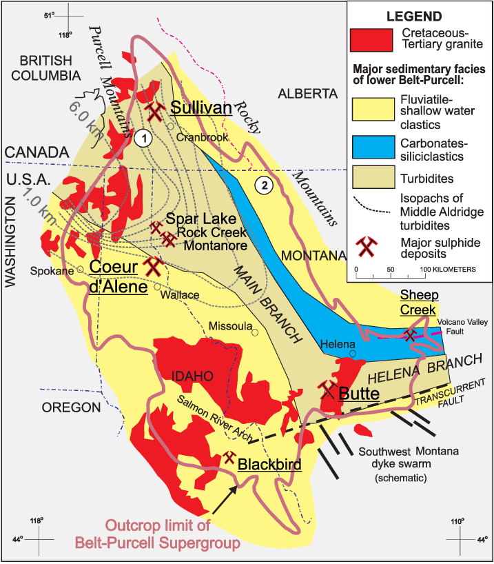
Full size / Map showing the outcrop extent of the Belt-Purcell basin, the locations of major mineral deposits, and the simplified distribution of sedimentary facies of the lower part of the Belt-Purcell Supergroup (i.e. Aldridge-Pritchard Formations and stratigraphic equivalents). (Source)

Full size / The middle Purcell Supergroup includes clastic sediments of the Creston Formation and carbonates of the Kitchener Formation. It is the middle Creston Formation, termed the Revett in Montana, that hosts the known copper deposits. (Source)
Excerpts from “An Evaluation of the Strata-Bound Base Metal Potential of the Middle and Upper Purcell Supergroup, Southeast British Columbia“ (2007):
“The Middle Proterozoic Belt-Purcell Basin hosts the Purcell Supergroup in southeast British Columbia. The basin is believed to represent an intracontinental rift system that has been filled by both marine and fluviatile sediments. The Sullivan Mine, one of the world‘s largest SEDEX Pb-Zn deposits, is hosted in the Aldridge Formation of the lower Purcell Supergroup. Overlying rocks of the middle and upper Purcell Supergroup have received much less attention in B.C., even though they host several important sediment-hosted copper deposits in Montana (Spar Lake [Troy], Rock Creek, and Montanore)... The Mesoproterozoic Belt-Purcell basin has sedimentary rock thickness of at least 19 km within the central part of the basin in BC and up to 18 km in the U.S. (Winston and Link, 1993). This large thickness of sediment was deposited in a relatively rapid period, leading to the formation of numerous sediment-hosted stratabound Cu-Ag occurrences in the quartzite-dominated Revett Formation. These deposits, including Troy, Rock Creek and Montanore, are all located in western Montana; however, evidence for sediment-hosted copper mineralization has recently been identified in southeastern British Columbia.“
Full size / Slabs of Belt Rocks Tell of an Ancient Basin: “Belt Rocks“ can be seen throughout much of western Montana, but one of the most interesting exposures can be seen along the Pintler Scenic Highway between Philipsburg and Anaconda. Here (above photo) the layers have been tilted, making the layers look like books leaning against a wall. Sedimentary rocks are formed in horizontal layers, but in northwestern Montana the horizontal layers of Belt rocks were messed up as colliding plates formed the northern Rocky Mountains roughly 80 million years ago. The mountains of Glacier Park formed as a large portion of Belt layers were thrust up and over younger sedimentary rock. Not only did this collision form many of the mountains of western Montana, but it also exposed layers that were buried deep beneath the Earth, giving geologists a look farther back in time. (Source)
Excerpts from “Mesoproterozoic Belt Supergroup“ (2021):
The enigma of the Belt Supergroup is well-summarized by a quote from Dr. Don Winston (1931-2022), who worked extensively on the rocks of the Belt Supergroup while a professor at the University of Montana:
“The Belt was deposited in a huge intracratonic basin that stretched across western Montana , northern Idaho and into eastern Washington and Canada. It was filled by sand, silt, clay, and carbonate sediments that locally reach more than 18 km thick. The sedimentary structures of these rocks are beautifully preserved, since they were deposited 1.5 to 1.4 billion years ago. They reveal a world of pure sedimentary processes unfettered by plants and animals. [They] reveal a world of gigantic sheetflood alluvial aprons and shallow seas or lakes, for which there are no modern counterparts.“
The immense area (>200,000 km2) and thickness (>15 km) of the Belt Supergroup make it one of the largest sedimentary basins on Earth. It also was deposited prior to evolution of burrowing organisms and thus preserves some spectacular sedimentary structures. These features have helped the Belt Supergroup captivate the imaginations of generations of geologists and the details are still being worked out.
Belt Supergroup rocks were deposited in the largest Middle Proterozoic basin on the North American continent. Most workers interpret that the Belt basin was formed as an intracratonic basin and periodically connected to the world ocean. At other times, it was enclosed and formed lacustrine deposits (Ross and Villeneuve, 2003). Though most workers agree that the basin formed during rifting of the 1.45 Ga Middle Proterozoic supercontinent Nuna, there is extensive debate about whether extension resulted in formation of an ocean basin and complete continental breakup or if rifting failed prior to forming a major ocean basin. Plate reconstruction for this time period is not easy and is an active area of research. [End of quote]

Full size / Hypothesized plate tectonic configuration of supercontinent Nuna at ca. 1.6-1.3 Ga, showing the reconstructed position of the Belt basin (modified from Brennan et al., 2021). In this model, Australia and Antarctica are placed outboard (west in modern coordinates relative to Belt basin) of Laurentia. (Source)


The earliest rocks observed at Koocanusa are the sediments of the Creston Formation on the western side of the property. The east is dominated by younger rocks of the Sheppard and Gateway Formations, underlain by Nicol Creek Basalts. Evidence from the field suggests submarine eruptions (pillow lavas) and flows on land (vesicular lava). Sandstone beds have been observed between flows complete with ripple marks implying that the area was inundated by seawater periodically. The basalt rocks eventually give way to the totally shallow marine environment of the Sheppard Formation. These include fine-grained silts, stromatolites and limestone.
At the top of the Sheppard Formation, layers of dolomite persist before passing into the silt and sandstones of the Gateway Formation. These layers also contain features such as mud (desiccation) cracks, salt (halite) casts, rip-up clasts, ripple marks and even rain drop imprints, all formed within a shallow lagoonal environment prone to “drying out”. The Gateway rocks give way then to purple-red (oxidized) sands of the Phillips Formation which are highly distinct due to their colour. These were deposited by a river one the foreshore of a shallow sea, possibly in a delta. The entire stack shows a change from a dry, volcanic environment to one of active shallow seas and coastal features. This is a “transgressive” sequence, either caused by rising sea-levels or the sinking of the basin floor at the time. This is most abrupt at the Nicol Creek – Sheppard interface, as sedimentary layers above this suggest receding / shallowing water levels.
PHILLIPS FORMATION
The Phillips formation is a relatively minor bed at Koocanusa and has only been observed in the southwestern part of the property. It comprises of a purple to red, fine-grained and micaceous sandstone with occasional argillite layers nearer the top of the formation. Volcanic ash from the equivalent formation in the United States (the contiguous Bonner Formation) has a Uranium-Lead isotopic age of 1,401 million years (+/- 6 million years).
GATEWAY FORMATION
The Gateway Formation overlies the Sheppard Formation. It is comprised of fine-grained, light grey-green siltstone and sandstone with minor dolomitic limestone. The base of the Gateway Formation is marked by the first occurrence of salt casts, mud cracks, and rip-up clast beds within siliceous fine-grained sediments that overlie the massive dolomitized limestone beds that mark the top of the Sheppard Formation. Sedimentary facies of the Gateway Formation fine upwards from predominantly fine-grained sandstone at the formation base to fine-grained siltstone and argillite at the formation top.
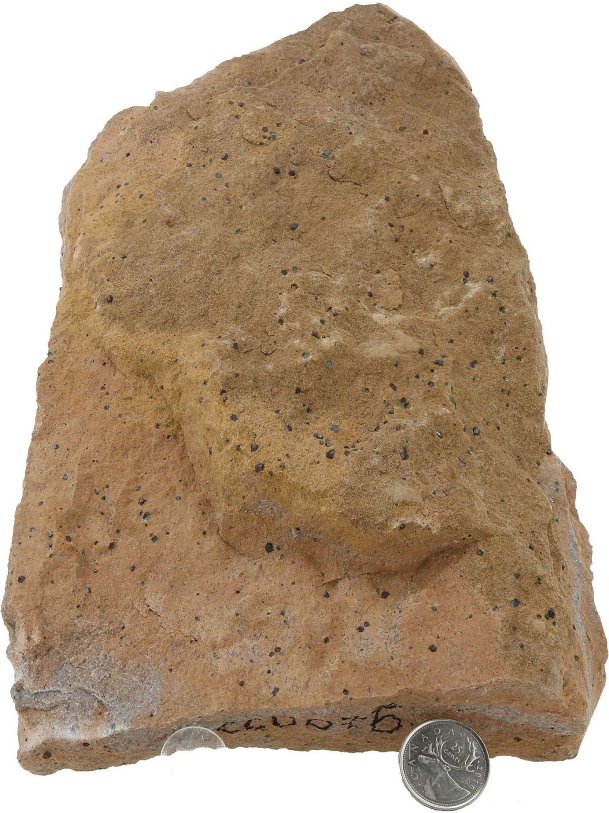
Full size / Medium-grained buff-coloured sandstone with numerous garnets. This unit is porous and has allowed fluids to transition through, forming not only the garnets but also contributing to the copper anomalies.

Full size / Cherty siltstone with loose bands of cinnabar (mercury), found within zone of historical copper anomalies.
SHEPPARD FORMATION
The Sheppard Formation is comprised of fine-grained sandstone and dolomitic limestone, and unconformably overlies the Nicol Creek Formation. Sedimentary facies of the Sheppard Formation grade from siliciclastic sediments at the formation base, to stromatolitic and oolitic, dolomitic limestones at the top. A series of massive stromatolitic and oolitic dolomitized limestone beds mark the formation top.

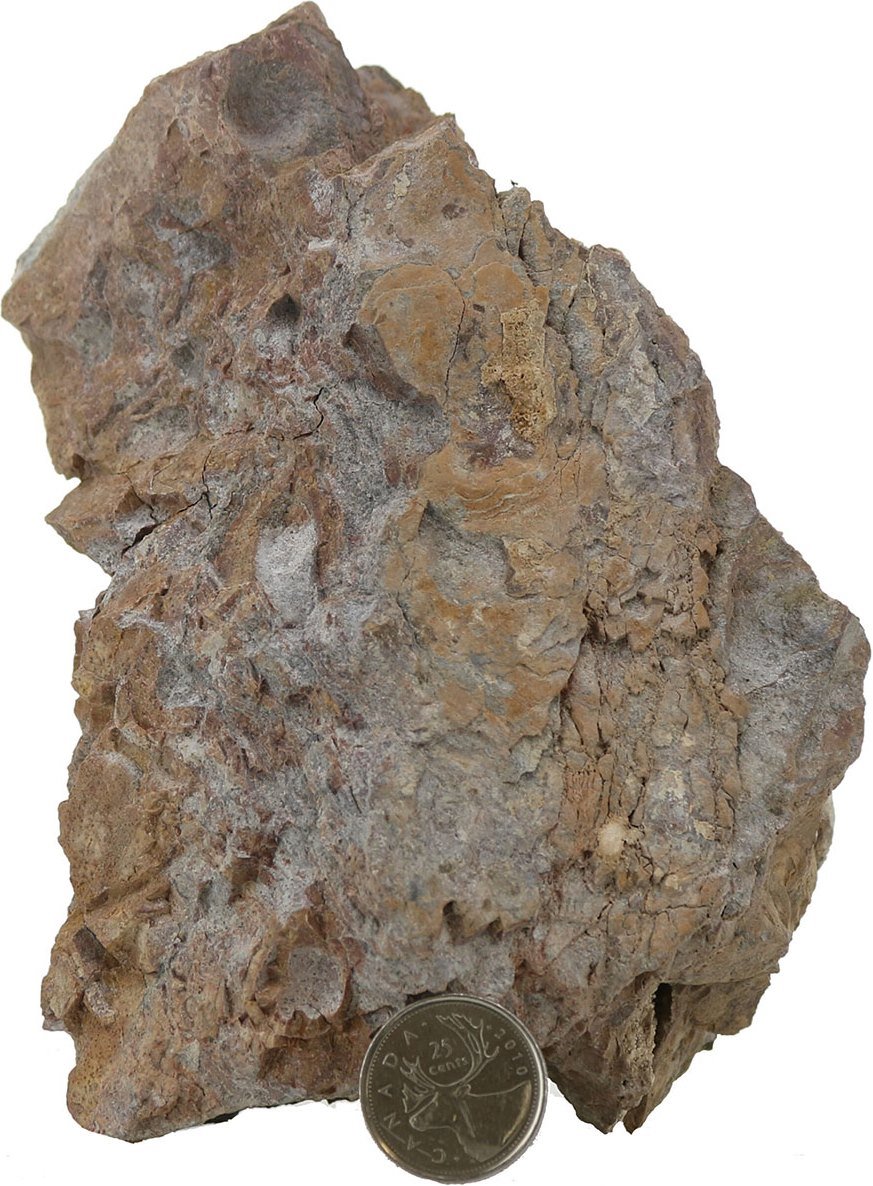
Full size / Large Stromatolite: The sample shown here represents one of the larger stromatolites found on the property. When complete, it would have been about 40cm in diameter and stood 30cm tall off the seabed.
Full size / Stromatolites (photosynthetic cyanobacteria) in a silty dolomite unit found near the contact with the underlying Nicol Creek Basalts. These are significant as they indicate shallow marine environments.

Full size / Polished slab of small stromatolites.
NICOL CREEK FORMATION
The Nicol Creek Formation is comprised of amygdaloidal and phenocrystic basalt flows, shallow marine volcaniclastic to siliciclastic sediment, and minor tuff. Zircon from a rhyolitic tuff within the contiguous Purcell Lava in the USA has a U-Pb age of 1443 +/- 7 Ma.

Vollbild / Quartz vein with jasperized basalt clasts.

Full size / Vesicular basalt slab.
VEIN STYLES
A wide range of veins occur across the Kookanusa Property, from thin quartz-carbonate stockworks to half-meter-wide quartz/barite/magnetite veins. The majority of the large vein systems have been observed in the Nicol Creek Basalts, where the brittle rocks allowed for the formation of wider fractures. In the overlying Sheppard Formation, these veins quickly become more diffuse as fluids pass into porous sandstones or the reactive dolomites. The theory is that these veins are synsedimentary, i.e. they are forming at the same time as the sediments are deposited and so these rocks do not have a brittle fracture. The veins observed in outcrop contain extensive mineralization and oxidized “ghosts” of crystals, sometimes replaced by later infill. Studies are underway to determine the full mineralogy, genesis and potential of these veins.
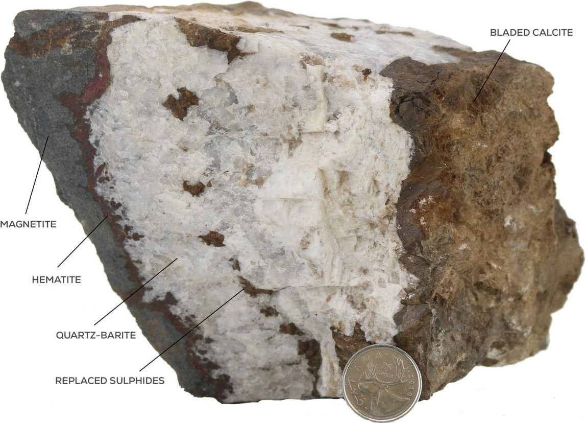
Full size / Barite-Quartz-Magnetite vein with hematized wall rock, boiling textures and oxidized suphides within the vein. This sample was hosted in Nicol Creek Basalts.

Full size / Geodes within Nicol Creek Basalt – open voids, well developed quartz and barite crystals with hematized/magnetite-altered wallrock.

Management & Directors
Andy Randell (Chief Geologist, Director, Founder)
Andy is a professionally registered geoscientist, and a white settler of English ancestry, living as a guest on unceded Musqueam, Squamish, and Tsleil Waututh territory. He graduated from the University of Cardiff (Wales) in 1998 with a Bachelors degree in Environmental Geoscience, but initially specialized in paleontology. He took a break from geology due to a lack of opportunity in the United Kingdom in the early 2000s, and so worked in the banking sector as a Financial Planner working on developing new “green” and ethical funds. In 2003, he made contacts within the industry and was eventually offered an opportunity to work as a Geotechnician for projects in Guyana. This eventually led to projects in the Yukon territory, first as a Project Geologist for Victoria Gold Corp. (TSX: VGCX; current market capitalization: $480 million), and then Chief Geologist for Ryan Gold Corp. (acquired by Oban Mining Corp. in 2015; now Osisko Mining Inc.). The economic downturn in 2011/2012 forced Andy to diversify, which is where he established his consultancy, SGDS Hive, working with a wide range of clients and projects. He also established the non-profit Below BC, which performs outreach and educational opportunities in geoscience. In 2016, he received the Bedford Young Mining Professional Award through the Canadian Institute of Mining (CIM). Currently, Andy sits on the Board of Directors for the Association of Mineral Exploration (AME), and is the Chair of the CIM Geological Society. In 2020, Andy also took an opportunity to teach two 4th-year university courses at the British Columbia Institute of Technology, namely the Indigenous Relations & Sustainability course and Mining Law & Ethics. Andy founded Aeonian Resources Ltd. to explore a more sustainable and transparent form of mineral exploration with the hope to inspire change at the grassroots level.
Branden Haynes (CEO, Director)
Branden is an entrepreneur with transferable experience in the junior exploration space. In addition to Aeonian Resources Ltd., he is also the CEO and founder of Hawkmoon Resources Corp. (CSE: HM). He has previously guided Hawkmoon through the initial financing phases, project acquisitions, deployment of exploration programs and development financing and IPO. Branden has >20 years of experience in finance and the junior markets. Additionally, he is a resource professional and entrepreneur active in the exploration and mining sector for >15 years.
Jasmine Cherian (CFO, Director)
Jasmine is an analytical professional with solid educational background with experience in performing financial accounting responsibilities. She graduated from the University of Calicut (India) in 2016 with a Bachelors Degree in Business Administration. She has also graduated from the British Columbia Institute of Technology in 2020 with an Advanced Diploma in Accounting. Jasmine has furthered her education as a CPA candidate with plans to write her CFE in late 2022. Jasmine has >5 years of experience in the accounting industry. Adept at prioritizing tasks and completing those in a timely fashion, she thereby produces positive results.
Technical Advisor
Dr. Olga Ankindinova
Olga is a strong research-oriented professional. Demonstrated history of working in the environmental sector, university environment, oil and gas, and mining industries. She has a Bachelor’s degree in Geology, followed by a Master’s degree in Marine Geology with an emphasis on stream sediment transport and accumulation. Her Ph.D. project at Memorial University of Newfoundland was focused on High-Resolution Sequence Stratigraphy of the world’s largest anoxic basin and involved work with geological, geochemical, and geophysical datasets. Her work was published in highly visible journals (e.g. Marine Geology, Paleo3) and presented in national and international conferences. During her career as a geologist, Olga worked on a number of projects contributing as a specialist in sedimentation in different depositional environments. During her Ph.D. program, she worked with Husky Energy Inc. in St. John’s, in the Development Team (Offshore Newfoundland). Her projects were focused on the development optimization and assisting in well planning by focusing on geological characteristics of formation. Olga is passionate about solving complex geological problems and paleo-reconstructions. She was twice awarded the Chevron Canada Rising Star Award. Outside her job you can meet her in the North Shore hiking, biking and skiing with her children.

The word aeon, also spelled eon, originally meant “life“, “vital force“ or “being“, “generation“ or “a period of time“, though it tended to be translated as “age“ in the sense of “ages“, “forever“, “timeless“ or “for eternity“. Although the term aeon may be used in reference to a period of a thousand million years (especially in geology, cosmology and astronomy), its more common usage is for any long, indefinite period. Aeon can also refer to the 4 aeons on the geologic time scale that make up the Earth‘s history, the Hadean, Archean, Proterozoic, and the current aeon, Phanerozoic. (Source)
Company Details

Aeonian Resources Ltd.
Suite 330, 470 Granville Street
Vancouver, Canada V6C 1V4
Phone: +1 604 349 2090
Email: hello@aeonianresources.com
www.aeonianresources.com
Canada Symbol (CSE): Not listed
Germany Symbol: Not listed
Contact:
Stephan Bogner (Dipl. Kfm., FH)
Rockstone Research
8260 Stein am Rhein, Switzerland
+41-44-5862323
info@rockstone-research.com
www.rockstone-research.com
Disclaimer: This report contains forward-looking information or forward-looking statements (collectively "forward-looking information") within the meaning of applicable securities laws. Forward-looking information is typically identified by words such as: "believe", "expect", "anticipate", "intend", "estimate", "potentially" and similar expressions, or are those, which, by their nature, refer to future events. Rockstone Research, Zimtu Capital Corp., and Aeonian Resources Ltd. caution investors that any forward-looking information provided herein is not a guarantee of future results or performance, and that actual results may differ materially from those in forward-looking information as a result of various factors. The reader is referred to the Aeonian Resources Ltd.´s public filings for a more complete discussion of such risk factors and their potential effects which may be accessed through Aeonian Resources Ltd.´s profile on SEDAR at www.sedar.com. Please read the full disclaimer within the full research report as a PDF (here) as fundamental risks and conflicts of interest exist. The author owns equity of Aeonian Resources Ltd., and also holds a long position in Zimtu Capital Corp., and thus may also benefit from volume and price appreciation of those stocks. The author is being paid by Zimtu Capital Corp., which company holds an equity position in Aeonian Resources Ltd., whereas the featured company Aeonian Resources Ltd. pays Zimtu Capital Corp. for the preparation, publication and additional distribution of this report.