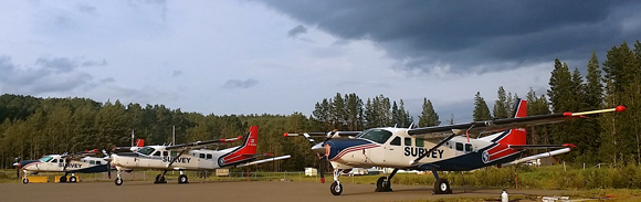
Outfitted with sensitive magnetometers, three Cessna Super Caravans will fly the largest survey in Geoscience B.C.’s 11-year history. (Photo: Geoscience B.C.)
It’s probably one of the biggest geophysical surveys underway anywhere. Pilots now have three magnetometer-equipped Cessnas criss-crossing an especially rugged 24,000-square-kilometre expanse of west-central British Columbia on tight, 250-metre linespacing. This is Search Phase II, part of an even bigger project that will make “a generational contribution to better understand the area’s geology and mineral potential,” says Bruce Madu, VP of minerals and mining for Geoscience B.C. But the results will hardly be limited to industry. The non-profit’s mission is to access “earth science for everyone.”
Data of this quality rarely finds its way to junior explorers, let alone prospectors. But proprietary software makes it available to anyone with an internet connection. Besides mineral opportunities, practical advantages include land use planning for regional districts, local communities and First Nations.
The grid extends from Fort Fraser to Smithers, building on two previous surveys. Last year’s Phase I flew over neighbouring terrain between Terrace, Kitimat and Smithers. The 2013 TREK program covered an area bounded by Vanderhoof, Fraser Lake and Quesnel, conducting sampling and mapping, as well as airborne mag. The three surveys combined will cover 55,500 square kilometres, about the size of Nova Scotia.

When combined with two previous surveys, this year’s program will provide magnetic data for 55,500 square kilometres. (Photo: Geoscience B.C.)
TREK’s inspiration came from the Blackwater discovery, now New Gold’s (TSX:NGD) proposed open pit mine with reserves of 8.2 million ounces gold and 61 million ounces silver. Yet “the surrounding geology is poorly understood,” Madu says.
The Phase II flyover includes another proposed mine, Pacific Booker Minerals’ (TSXV:PBM) Morrison copper-gold project, as well asThompson Creek Metals’ (TSX:TCM) majority-held Endako molybdenum mine and the former Bell-Granisle copper-gold mines. The survey just bypasses Imperial Metals’ (TSX:III)50%-held Huckleberry copper mine.
Low prices put Endako on care and maintenance, with Huckleberry slated to follow this summer. But Geoscience B.C. helped extend the latter mine’s life by about two years, Madu says. “We flew some geophysics, the company participated and ended up drilling new ore. A couple of hundred jobs were given a couple more years.”
The region “clearly has substantial mineral potential,” Madu points out. “Even more importantly it has excellent infrastructure, lots of road networks, there’s rail in the area and hydro nearby, so it can be quite a cost-effective place to discover and develop a mine.”
Having just reconnoitred with the Search Phase II crew, Madu waxes enthusiastically about the staff, the three Cessna Super Caravans especially suited for this survey’s challenges, the ultra-sensitive magnetometers and the preliminary data. “It excites me—the quality is superb.”
Phase II comprises one of 13 projects scheduled for this year, with a budget totalling $2.5 million. “They cover all sorts of perspectives,” Madu says. “We’ll be active in the Sheep Creek, Barkerville and Cassiar gold camps, the Toodoggone region, we’ve got a mapping crew south of Terrace working on last year’s geophysics, we’ll be east of the Penticton gold camp around the Boundary area. We have chemistry projects re-analyzing almost 5,000 archive samples from southeastern British Columbia as well as the Atlin area. And we’ve got a lot of value-added projects on the go this year, taking existing data and putting together a more complete picture combining geophysics, geochemistry and geology, which I think is a big advantage for the industry’s future, being able to have these super-sized data sets.”
Not limited to mineral exploration, Geoscience B.C. also conducts surveys related to areas such as oil and gas, geothermal energy and groundwater.
“On the minerals side, during our 11 years of operation we surveyed a large portion of the province with geophysics, we re-analyzed almost the entire suite of geochemical samples for the province, we provided a lot of innovative research in glacial tills and tree-top sampling, we funded new geochemical methods using water in the field as well as capturing gases and sampling organic materials. So in addition to fundamental baseline data creation, we do a lot of innovative research as well.”
Next year’s plans call for Search Phase III extending northeast to the Quesnel copper belt and covering a region that hosts Imperial’s Mount Polley copper-gold-silver mine, the auriferous turf of Barkerville Gold Mines TSXV:BGM, Thompson Creek’s Mount Milligan copper-gold operation and AuRico Metals’ (TSX:AMI) gold-copper-silver deposits at Kemess.
Looking further ahead, Madu sees the organization “looking at the mining cycle instead of just exploration to see what we can do to help the development or efficiency of mining. We might look at research into subjects like water, tailings and metallurgy, for example.”
The group was founded in 2005 when the province put up money as an inducement to industry contributions. A lot of those contributions come from preferred rates or volunteer work supporting a small staff. Regional trusts have also contributed. Last May the province forked over $5 million.
The results of all that go online, available to everyone. Geoscience B.C.’s Earth Science Vieweropens with a satellite image of the province. Users can zoom in on a particular area, load a layer of data from the selections to the left, then overlay additional data. New info comes online as survey results are processed. Mineral tenures are updated daily, with links to the government’s database of claimholders.
“Viewers can put the tie-dyed geophysical charts on top of the geology layer to see how they agree or don’t agree,” says Madu. “I think that’s quite a powerful prospecting tool because one thing we want to do is challenge assumptions. If the geology and geophysics are telling different stories, we want people to research that and explore it.”
A planned upgrade, possibly within a year, will make the viewer three-dimensional, “something like Google Earth where you can tip it on its side and fly around valleys a bit,” he adds.
With a wealth of practical info for industry and communities alike, the viewer “puts the power of information into the hands of people who can use it.”
Source: http://resourceclips.com/2016/07/29/earth-science-for-everyone/
